|
Ocean Acoustic Tomography is a tool with which we can study average
temperatures over large regions of the ocean. By measuring the time it
takes sound to travel between known source and receiver
locations, we can determine the soundspeed. Changes in soundspeed can
then be related to changes in temperature.
Because this technique integrates temperature variations over a large
region, the smaller scale turbulent and internal-wave features that
usually dominate point measurements are averaged out and we can better
determine the large-scale dynamics.
Although travel times must be measured to a nominal accuracy of 1 millisecond, tomographic
transmissions consist of long coded signals lasting 30 seconds or more. These transmissions
are audible near the source, but over most of the ocean they are below ambient noise levels,
requiring sophisticated spread-spectrum signal processing techniques to recover them. Near
the source a typical tomographic signal has a distinctive gurgling sound like this computer
generated signal.

Greenland Sea Tomography Experiment
In 1988-89 a six-element tomographic array was moored in the abyssal
plain of the Greenland Sea Gyre
to study deep water formation and the gyre circulation.
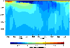
Tomographic observations of
range-averaged temperature profiles along
one path show a warm surface mixed layer in the fall, which cools to
the freezing point by late November. For the next several months dense
ice covers this region, but although the surface mixed-layer remains at the
freezing point it deepens very little. In February and March this path
becomes largely ice free, and the mixed-layer rapidly deepens to about
1500m while dramatic surface cooling occurs. The sun rises above the
horizon again in late March, and the heating of the water column
results in another warm surface mixed layer.
Daily satellite observations of the surface ice cover are formed into a
movie.
Note the dense ice cover over the array in December and
January, followed by very rapid changes until April. During the later
part of the winter, the region above the region discussed above always
remains ice-free, whereas the surrounding regions are repeatedly
covered by ice.
The Greenland Sea Tomography Experiment was a collaboration with
members of the Scripps Institute of Oceanography (La Jolla, CA). More
details of this analysis can be found in Pawlowicz et. al, "Thermal
Evolution of the Greenland Sea Gyre in 1988-1989", Journal of
Geophysical Research, Vol.100, No.C3, pages 4727-2750, March 15, 1995.
Barents Sea Polar Front Tomography Experiment
In August of 1992 a three-element tomography array was deployed in the shallow
shelf region east of Bear Island in the Barents Sea to study the frontal
dynamics in this region. This movie
(courtesy of NPS) shows tomographic observations of
temperature across the front at 10 minute intervals for about 10 hours.
The Barents Sea Polar Front Tomography Experiment was a
collaboration with the Naval
Postgraduate School (Monterey, CA) and SAIC. More
details of this experiment can be found in Parsons et. al, "The Barents
Sea Polar Front in Summer",
Journal of Geophysical Research, 1994.
THETIS-2

In 1994, the THETIS-2 tomography experiment took place in the
Western Mediterranean. In collaboration with members of the Institut
fur Meereskunde (Kiel, Germany), IFREMER (France), and JAMSTEC (Japan),
we deployed one instrument in an seven-element tomographic array
which was designed to measure seasonal heat content changes in this
region. The S-Tether design of this mooring allowed us to telemeter
data in real time using the ARGOS satellite system. Engineering and
acoustic data from this mooring were
replotted every day as new information was received.
On June 6th, after 5+ months of perfect performance, the ARGOS
transmitter went off the air.
Postcruise examination of the mooring cable, along with the mooring navigation
data, showed that fishing activity likely caused the interruption in the
telemetry. However, the tomography data was also stored internally so that
no valuable arrival time data was lost during the experiment.
More information can be found in an article by Dr. James F. Lynch in
"Sea Technology", Vol. 36, No. 9, September 1995, pages 25-31.
|
